Design meshes merged with topography surfaces giving you trouble? Here's what to try...

While working on improvements to our Leapfrog Works Fundamentals learning pathway, I was reminded how challenging it can be to work with design meshes as part of a topography surface.
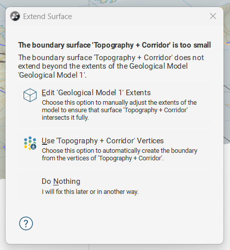
If you've ever tried to create a geological model using a topography surface that includes a merged design file (like a highway cutting, excavation, or other surface geotechnical design) you might have encountered the error:
“The boundary surface [Topography] is too small.”
The best way to fix this is to clean the mesh in a third-party mesh editing software and then reload the fixed design file into Leapfrog. This ensures the design surface is free of problematic edges and ready for modelling.
But if mesh editing isn’t an option, Leapfrog offers several helpful workarounds:
🔧 Edit GM Extents
Manually adjust the geological model extents to exclude the problematic areas of the design mesh.
📍 Use Topography Vertices
Convert the mesh vertices into a Points object to define the upper boundary of your model. Just note that this breaks the link to the original topography surface, so future updates must be done manually.
📤 Export and Reload as Elevation Grid
Export the merged mesh as an elevation grid and re-import it as a new topography surface. This simplifies the geometry and can resolve extents issues.
These options can help keep your modelling workflow moving, especially when working with complex geotechnical or civil design surfaces.
Have you run into this error before? What’s worked best for you? 👇 Share your tips or questions in the comments!