Best Of
Re: 💥 Exciting Updates in Visible Geology!
Hello! I’m a teacher from China and a huge fan of Visible Geology. I use your tool constantly in my classroom to help students visualize geological concepts, and it has made such a difference to my lessons.
Recently, I noticed that Visible Geology now requires a Google account to log in. Unfortunately, Google services are inaccessible in China, so I’m no longer able to use the tool with my students.
I was wondering if there’s an alternative login method, such as an email/password sign-up, or any other solution that would allow me and my students to keep using Visible Geology.
Thank you so much for creating such an amazing educational resource. I really hope we can find a way to keep using it in our classes.

Re: 💥 Exciting Updates in Visible Geology!
Hi Jinxianhuang
Thank you so much for your kind message and for using Visible Geology in your classroom. We’re really glad to hear it’s been helpful for your students.
Can I still use Visible Geology without a Google account?
Yes. You and your students can still access and use the Visible Geology modules without logging in.
What won’t work without Google login?
Features that require an accoun,: groups, assignments, and saving work, are now only available when logged in with a Google account.
Why was this change made?
The move to Google login was a company‑wide decision to keep Visible Geology secure and sustainable long‑term. Supporting multiple login systems would have made access more complex and harder to maintain in the future.
Is there an alternative login (e.g. email/password)?
At this time, no. We understand this is particularly challenging in regions where Google services aren’t accessible, and I will take account of this feedback internally.
Thank you again for your support and for reaching out! We truly appreciate it.
Kind regards,
Elisabeth
Re: Alpha-beta-gamma-WHAT?
Yes, James totally agree !
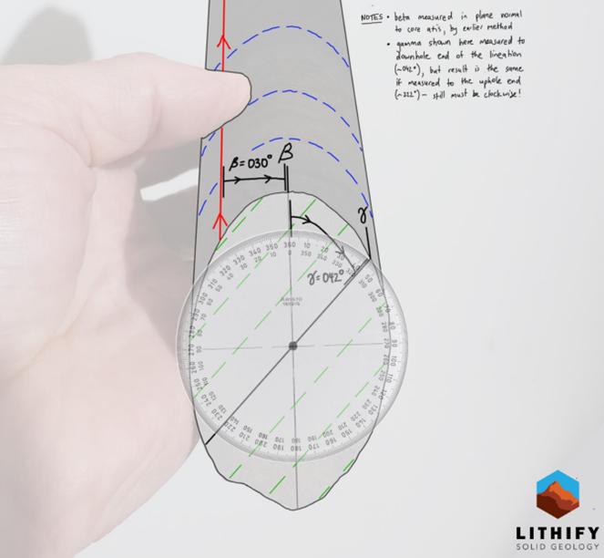
Using a protractor on the plan will be the best way to measure γ. See picture below. I'm sorry, but I haven't been able to trace the source of the image, even using Lithify Solid Geology

Re: Alpha-beta-gamma-WHAT?
For lineations on a plane, note that the gamma angle has to measured ON the plane, and not in the same way as a beta angle measurement around the core circumference - the angles are not equivalent except at 0, 90 and 270 degrees. The lineation also has to be measured as though it is passing through the core centre point, which make A-B-gamma a challenging way to get orientations of things like fold axes.
Re: Multiple samples per field point in MX Deposit
DK: "We have tossed around the idea of having a sort of special "coordinate" table that has built-in northing/easting/elevation/CRS columns that would also make use of the coordinate transformation features on export. That would let you capture different XYZ values for different samples in the same table, then the point header could just be some logical grouping of samples."
This actually could be useful for cases where point data is captured outside of MX Deposit and imported, but analytical data processed in MX. Akin to acQuire "Geochemistry" Holetype which is triggering use of XYZ on a sample level with HOLEID used as a campaign name (or any other logical grouping of surface samples).
Re: Alpha-beta-gamma-WHAT?
HI Andrew,
Thanks for this remind especially γ which is omitted a lot of time.
I would like to point out that you also need to determine the kinematics of your structure – specifically, whether it is sinister or dextral, normal or inverse. A line measurement without the kinematics is useless.
Regards,
Re: How do I create a surface with limited data using Geo model tool?
If you're looking at the 'output volumes' only in a geological model, remember that you have to make the surface 'active' first by double-clicking the Surface Chronology and ticking the box to the left of the object in the list. Only then will the volumes be generated. Until then, you can open the object from the Surface Chronology list to check it first.
Otherwise I'm not sure from your description where you are having trouble. I'm assuming you have set up a Geological model to reference the "weathering" column in your drill hole data as the Base Lithology Column and then set up a Deposit (or erosion) surface under Surface Chronology. Take a look at the Help files or one of the Leapfrog training videos to see how this is done in more detail.
Alpha-beta-gamma-WHAT?
A really common question we get at Seequent is about structural measurements made in drillcores. So much so, that we made a dedicated guide to using downhole structural measurements in Leapfrog.
There's a couple of things to know up-top:
1 - If your drillcore isn't orientated, you cannot use the downhole structural measurement tools in Leapfrog. This may change in the future, but for now only orientated drillcores and their data are accepted.
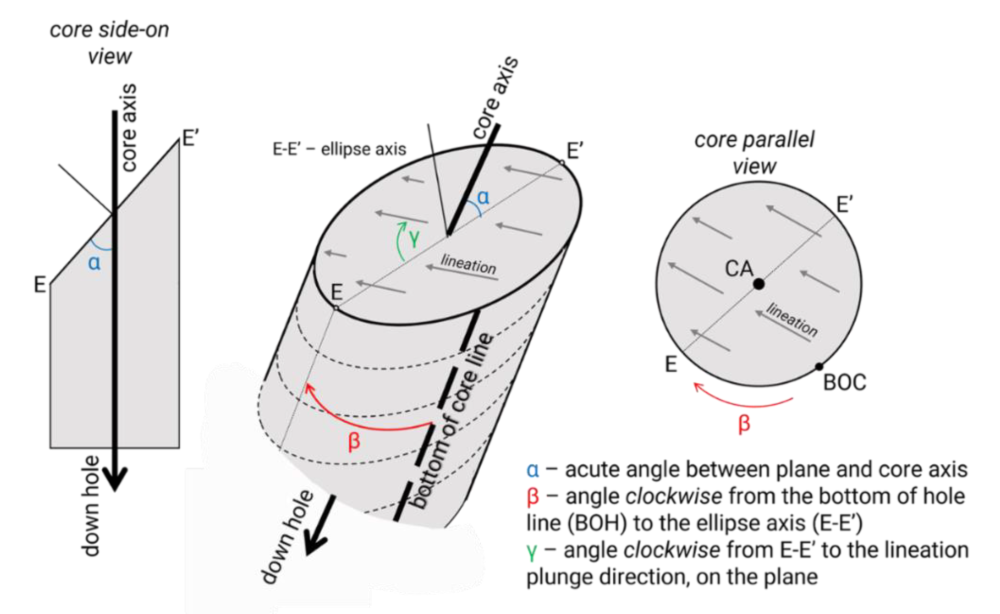
2 - Leapfrog uses the α - β - γ notation, where:
- α is the minimum angle between the core axis and the geological plane, along the ellipse axis (E-E');
- β is the angle of rotation about the core axis between the 'bottom of core line' drawn on the drillcore and E;
- γ is the minimum angle of rotation about the core axis between E-E' and a lineation.
α - β - γ are shown below.
There are alternative methods used in the mining industry and there is no global standard. The α - β - γ method is probably the most commonly used and is certainly the most commonly cited in academic and technical literature.
For more details, including references to the α - β - γ method, look at the attached PDF and the Leapfrog Structural Modelling 1 of 6 | Structural Data course at Seequent Learning.

Re: Combining a topography mesh with a cross section
Hi Edward,
Without seeing your cross section I reckon that you could crop out some of the white during image import or increase the transparency of the cross section in the scene. Or, perhaps there is a third party image processing app or GIS that you could use to make the white areas transparent beforehand?